Beach Blogger's Had Yuan Trip Report - visited May 2012

Had Yuan is the closest beach with accommodation north of Had Rin. As such it tends to get busy around Full Moon Party time and in peak-peak season, but otherwise it is a pretty relaxed beach with a good choice of accommodation. And it has quick access by foot to two even more relaxed beaches just north - Had Thian and Had Way Nam.


Interestingly the ferry does not put in at Had Yuan (looks like the longtail mafia there have the beach tied up) - I had to jump out at Had Thian. The short but steep climb over to Yuan with bag was a good work-out.

Had Yuan. That's the rockside restaurant above. I think those bungalows closer the water are part of the resort. Most of Bamboo's bungalows are in a nice garden setting above the restaurant. The accommodation area is quite spacious, extending out of the top left of shot.
The track from Had Thian comes over near the communications aerial top right. 10 minutes between beaches.


.jpg)
The restaurant itself was a nice place to spend time. Excellent food taste-wise with presentation seeming to be a step up too. Prices slightly higher than average bungalow restaurants but well worth it - shown by plenty of people walking up from flasher resorts down on the beach to dine. Excellent friendly service - Bamboo is run by a Burmese family who prove the old adage - migrants try harder.

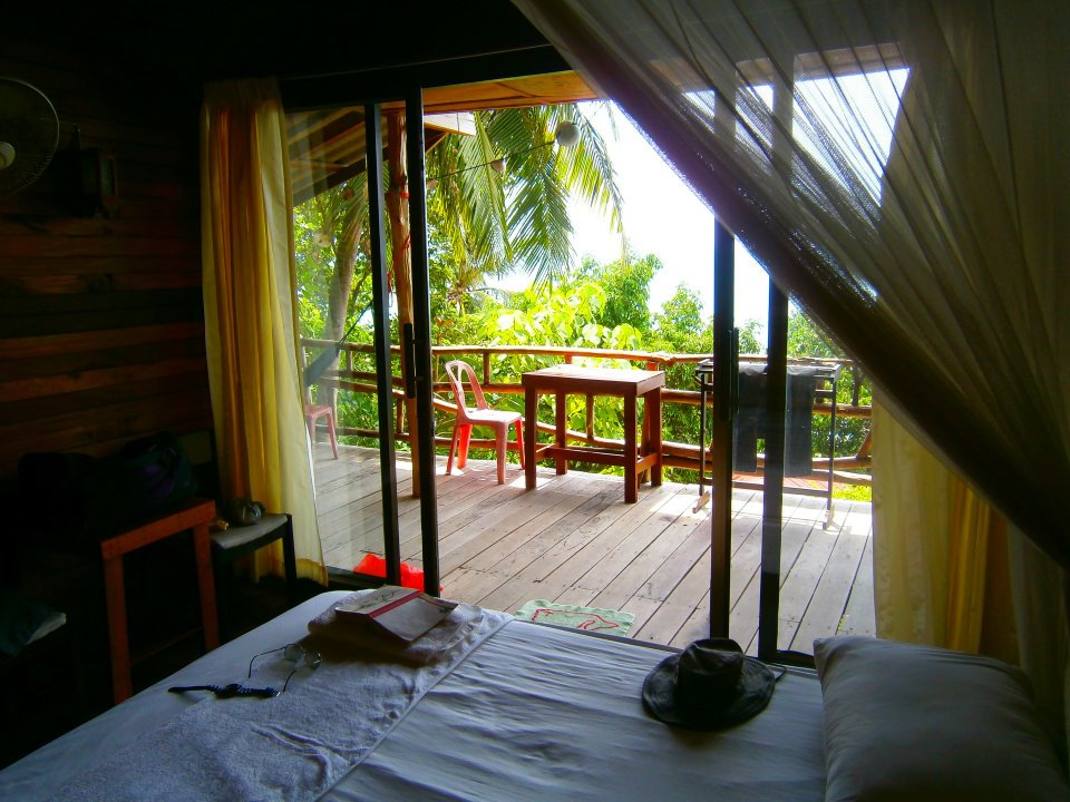
I went for the 400baht job (I didn't bargain), which made the 500baht tents in the wetter Andaman same trip look pathetic. The only difference with Bamboo's 350baht huts seemed to be distance from the restaurant/beach.
My hut was showing a bit of wear around the edges, had plenty of room for 2 and gear but not for a 3rd mattress. Comfy double bed with separate foam base, nice pillows, good net, okay fan - 24 hour electricity. Spacious bathroom, cold water, western toilet with bucket flush. Towel supplied but byo toilet paper. Good deck with hammock, drying rack, lotsa lines, broom. Nice garden setting manicured intensively by staff.
NOISE - a note of caution. On my first night around 0000 some pretty loud music kicked in. Went right thru to daybreak. Turns out this was a nearby bar down on the waterside rocks of the north headland. Second night all was quiet - long term visitors told me the parties are Tuesdays and Saturdays. I asked some guests down at the high end Pariya which is towards the far southern end of the beach if the music disturbed them - they said no. But sensitive people staying those nights at Bamboo, adjacent Eden or maybe those places on the northern end of the sand like Big Blue or Dream Bungalow should maybe take this into account.

There is a nice boardwalk along the southern headland - maybe 300m long. This has a bunch of budget joints leading off it. This is the restaurant-bar of Ocean Rock resort. I had to have a beer here - good views of beach and far headland (the 3rd shot from the opening of Bamboo Hut was shot from here). Other joints along the boardwalk include Good Hope and nearer the beach, Had Yuan Bungalows.
UPDATE MARCH 2017 - Ocean Rock has been taken over by Good Hope, which is now calling itself Club Bar Engage. However the affable Dutch owner is considering another name change. I stayed a few nights there on my 2017 visit to the area.

TREKKING AROUND HAD YUAN
10 minutes walk up over the northern headland gets you to laid back Had Thian. The Sanctuary was as atmospheric as usual - and I went back to my digs of June 2010, Beam Bungalows, for a meal. Good as before and I noticed that restaurant prices now seem at average budget bungalow levels instead of slightly over. I also noticed the 150 baht bungalow offered me was gone but there is still a very good array of bungalows at lower than normal prices. Nice place. Quite a few of the long termers who gravitated to Bamboo's rock sitting platform each night seemed to be staying at Beam.
There is no shortage of yoga places on Had Thian, not to mention all of the self improvement and healthful courses at The Sanctuary.
5 minutes over Had Yuan's northern headland gets you to even more laid back Had Why Nam - nothing had changed, still the one rustic budget bungalow joint with the yoga platform etc
I have pix and more info on Had Thian and Had Why Nam on the PHANGAN PART 2 PAGE.
THE HAD RIN TREK eluded me for years. After hopelessly miss-leading directions from the people at Bamboo Hut, I spent several hours looking for the START of the track from Had Yuan - following several false leads which ended in good old sessions of bush bashing. I HATE BUSH BASHING!
Finally I found the start of the track. You need to head out of Had Yuan on the new road which runs along the back of the beach and then turns west to climb over the high mountain divide to eventually meet one of the short roads up from the coast at Ban Kai. If you come up the Bamboo Hut access driveway you need to head right for maybe 200-300m. If you come up Big Blue's driveway, add 150-200m. See map below.
Thing is I lost so much time finding the track that 20 minutes up the slope I realised I had no chance of getting even to the Viewpoint above Had Yuan and back before sunset. Having no torch, I turned around.
No worries - next trip. I'm told the trek thru to Had Rin is 90-120 minutes.
SUCCESS! Yep, next trip I walked across from HAD RIN to see if SANCTUARY had a vacancy (I'm an old fashioned dude - don't carry a 'phone overseas - besides which I wanted to find out about the trek) and then walked back. 2 hours each way at my slow but steady pace was pretty right. The track was fairly easy to follow on account of markers, but pretty steep in some sections, particularly on the HAD RIN side. At the summit is a short side track which leads to an okay viewpoint over HAD YUAN. However nowhere could I find an unobstructed overview of HAD RIN.

The start of the trek across to Had Rin must be south of where Had Thian's access road hits the main road - I haven't walked this access road so I didn't try to include it. It would come in somewhere just out of shot top left.


UPDATE 2017 - a lady staying in my dorm at SANCTUARY did come in on this road. She told me it was horrendously steep, rough and treacherously muddy (it had rained a fair bit) and took 2 hours from BAN TAI. No wonder the dude with the ute quoted me 500baht (final destination is HAD RIN). A longtail from HAD RIN was costing 300 (still too high IMHO seeing boats rarely take off without 10 or so customers) and takes 10 minutea.

SERVICES - there is no village at Had Yuan. Big Blue has a small shop plus an internet cafe. I reckon the higher end places like Pariya and Barcelona might have similar. Over on Had Thian The Sanctuary has a shop, and bakes yummy goodies. It's not too far to Had Rin but a longtail aint cheap.
.jpg)
*****************************************
Beach Blogger's Than Sadet Trip Report - visited April 2012

I was so impressed with the view above when I climbed up from my Mai Pen Rai bungalow just over the beach below in 2009 that I decided to stay a few days at Plaas on my latest Phangan beach-hop. The fact that Than Sadet is a pretty nice location wherever you stay was significant too.
Transferring from Thong Nai Pan was pretty painless - I jumped on the small coastal ferry which beach hops down Phangan's east coast and then goes across to Samui each morning. Than Sadet is first stop - 150 baht.


Note the majority of Mai Pen Rai resort's Rockside Bungalows are stretched above the rocks for a good 300m past that hole. Mai Pen Rai also has Beachfront Bunglows and Riverside Bungalows.

You may be able to see the timber stairway out of the water onto that big rock around mid-frame - great for people with the emotional development of a 9 year old to climb up and jump into the water from a suprisingly high take-off. I had a ball.
Those bungalows at right some of Mai Pen Rai's riverside dwellings.
The next bay south is Had Thong Reng. Nice little beach and much clearer water. I found the snorkelling in both areas was not very good coral and fish wise.

Empty bungalows of Treehouse resort on Had Thong Reng - operators lost lease; presumably a new development is planned.


This is the most rewarding of the 3 in that there is a nice pool upstream in background good for swimming plus a slippery slide into a cave beneath a big rock (which still looked like it could be blocked this trip). Got a pic and more details on the Phangan Part 2 page.

THE ROAD INTO THAN SADET.
It took me about 50 minutes to walk right up to the new roundabout intersection with the main north south mountain road. All except the last 800m or so of this wallk is dirt - some rough, steep sections which will still need motorcyclists not used to such surfaces to take care on the descents. The last 800m to the main road is good concrete - hopefully this will be extended by the time you visit. The steep sections are not lengthy and not in the heart-breaking to walk up category unless you are unfit.


The restaurant has no views but is a nice place to spend time with good food and competitively priced beer. The bungalows from memory have tree filtered views similar to my Plaas' joint but 3 times the height. Hey for those of you who want an out of the way laid back place, this is your joint. Although Plaas did the same for me much closer the beach.


If you push on a short distance on the main path past the driveway entrance you will see the side track to the left for Hide on High.
To get back to the beach go back out of the side track and keep going east - the track drops steeply particularly once it hits a concrete driveway. Stay on this driveway for maybe 300m but where it curves left to some rich dude's villa, keep going directly ahead down the super steep-rough track which leads down thru Plaas to the beach. Maybe 10 minutes walk from Viewpoint.
Coming from the beach, continue up the path past Plaas' restaurant entrance and turn right.

*****************************************
Beach Blogger's Thong Nai Pan Trip Report - visited April 2012

After staying at Mae Had in the north-west I headed for Thong Nai Pan on account I'd heard Thong Nai Pan Noi beach is now completely dominated by one luxury resort. Gotta see that.

The trip from Mae Had was interesting. I could have come around by longtail providing I took out a mortgage on my house. So I planned to take a songthaew down to the pier at Thong Sala and jump on one of the waiting pickups to Thong Nai Pan when a ferry came in. I figured 400b or so if there were enough people to share - maybe 3 hours if connections worked without too much delay.
Fortunately a songthaew with a bunch of people was leaving Mae Had for the ferry (200b for them) and I managed to talk the driver into taking me all the way to Thong Nai Pan for 700 total (he wanted 1200). Gets better - after the pier we shot across to his nearby house and swapped into a newish aricon 4wd Toyota Hi-lux, leaving the songthaew to be driven by his missus. The total trip took maybe 50 minutes and I was dropped at the entrance to my resort.

Heading left in shot to Than Sadet the pavement goes for less than 1km - past there the road still needs fairly high caution in parts - say 3km.


Hey, pretty nice place - which probably accounted for the 90% occupancy in what was the very end of shoulder season. This joint has aircon bungalows, plus some bigger family places up the back.

Ther main changes to Thong Nai Pan Yai I noticed:
*My old favourite accommodation White Wind high on the southern headland has closed down. The land has been bought by Panviman high end resort - at the time of my visit the old bungalows were still there but Panviman was creeping around the headland with some new villas less than 100m away.
White Wind's rather nice beach bar perched just above beach level was still operating.
*The path up through White Wind and Panviman to Thong Nai Pan Noi has been blocked thoroughly, not partially as when I last visited.
*All the old budget favourites seem to have pushed upmarket - places like Candle Hut, Dreamland and Central Cottages now have pools and aircon/hot water - although most can still do less expensive huts.
THONG NAI PAN NOI
So has the midrange and better Anantara Rasanada completely taken over the beachfront? Well not quite - it dominates the place and there is not much evidence of the old budget joints we used to love.

Panviman stretches across the headland at left almost to TNP Yai now. At beach level starting at left (the southern end), the first 20% is taken by a new high end joint under construction.
Anantara Rasanada takes the next 55-60%, then there is a restaurant, a small section with flashpacker-lower midrange Phuwadee and the final 15% or so with the more budget Baan Tapan which has a popular beach restaurant.
If you click the shot to expand you will see the small rocky headland separating TNP Noi from Santhiya's separate small beach far right. There are budget bungalows on the headland - I couldn't confirm if they were run by Baan Tapan or had a similar name.
There is now a good path thru this resort joining Santhiya's beach to TNP Noi - just as well: the water off Santhiya seemed to have a plume and the original access road loops way around the back to the far south-west of town which made the restaurants and shops a bit of a stretch for Santhiya's guests.


Trekking Thong Nai Pan to Bottle Beach - and further.
I've never walked across to the north coast so this trip I decided to give it a go. I lucked-in when leaving Longtail resort because a songthaew was departing with people for the ferry at Thongsala so I got the driver to drop me at the Bottle Beach road turnoff for 40baht - this not only saved 20 minutes but also cut out the steepest climb. I was so fresh when I hit Bottle Beach about 40 minutes later that I decided to keep going to Coral Beach. Maybe not such a good idea - that super steep rough jungle track climb over the mountains takes 60+ minutes one way. When I finally got back to Thong Nai Pan I felt like I'd had a pretty good workout. Gave the beer section of the fridge in the Seven 11 a pretty good workout too.


The first 500m of the dirt road falls and climbs moderately steeply and then begins a slight uphill climb for 10 minutes or so. A few minutes along here a similar road (also with power lines branches to the left - I was told to follow the power lines) - keep going straight ahead......

The next 10 minutes or so is a steep downhill section. Take care if you are an unskilled motorcycists - dead easy to lock your brakes, slide into a rut and come down. A bloke wisely unloaded his girlfriend to walk with me while he slowly made his way down - we actually got ahead of him at one stage.

At the bottom of the hill the track flattens out for the final 10 minutes. I reckon time from beginning of dirt road near towers was abt 40 minutes. From the TNP beaches - 60 minutes.

As a matter of interest, adjacent Haad Khuad Resort was handing out brochures at the ferry with 3 person fan bungalows at 380b, 2 stories 2 bedroom beachfront fans at 850 and Hotel Sea View rooms with the works for 1200 and discounted transport. Dunno if this place has a pool yet - BB One has (see down page).
Oh yeah, Bottle Beach 2 down the far eastern end of the beach had recently refurbished the bungalows. This budget place looked pretty attractive unlike my previous visit.

Note it would not be a real good idea to come fanging over the hill in background at warp speed on your hire Honda. This trip I noticed someone had rigged up some makeshift barriers just before the top. Last trip I noticed some pretty good skid marks.

Resort had some simple fan bungalows with similar views for 300. From memory their same type shacks overlooking the beach were also 300. Gotta stay here one day!
Um, so after that pleasant interlude - back to Thong Nai Pan Yai (far end!) which included the super steep track to Bottle Beach and that steep rough road climb out of Bottle Beach. Probably 2.5 hours.
***********************************************
Beach Blogger's Mae Had Trip Report - visited April 2012

Mae Had (Had Mae, Haad Mae etc) is at the very north end of the west coast. Most Phangan visitors call in on one of the around-island boat trips or motorcycle in for a visit because it has the best snorkelling at Phangan. However the nice beach, a good variety of places to stay and a laid back atmosphere has resulted in it becoming a favoured destination for return visitors. Many of these are the backpackers of the 80s and 90s so family groups are common. But younger singles and couples also feature, although this beach is short on entertainment for ragers.


Mae Had's 3 main beach areas shot from Ko Ma - the small offshore island (you can see the sand spit joining Ma to the main beach area at low tide in the left of shot). Mae's Main Beach is at center, the Northern Beach background left and the Southern Beach background right. These will be clearer if you click to expand.

Like all west coast beaches Mae Had gets the low tide blues as in shot. At such times you need to wade out a fair distance to be able to swim - best in the middle where rock has been cleared to allow the daytrip longtails to get into the beach.

Bungalows belong to Island View Cabana - a nice flashpacker place with a scenic and reasonably priced restaurant overlooking the spit to Ko Ma. Has an internet cafe. Plus wireless of course - most bungalow joints do these days.


Hey, nothing wrong with the restaurant - nice outlook and good food, drinks at lower rates than the average budget bungalow - try 70 baht for a LARGE Chang (lotsa places want that fer a small one in 2012).
Friendly staff, spent ages each morning manicuring not only the bungalow area but the extended beach in front. There is a creek runs between the restaurant and the water - you can see the access bridge at right. I came in after dark, no moon - glad I had my torch.

Remember there is a creek between camera and shot - nevertheless I regard mine as beachfront.
This place has 3 rows 0f bungalows - the third is elevated on the lower slopes of the hill, has some views.
My concrete walled - tiled roof place was just big enough for 2 + gear. No shelves but a neat storage alcove. Good window screens. Comfy king bed.Good lights, fan a bit noisy. In good condition - looked like they had been remodelled not too long ago. Clean. Very quiet at night (except for the thunderstorm!) Flush toilet, HOT water, towel and toilet paper, no soap or bottled water.

Tel (66)8-004-4453-9

Around Mae Had

If you climb the track to within 200m of the main road (maybe 10 minutes), you will see a sign to the left: WATERFALL. Take the steep path down the hill - veer left at the houses until you hit the creek and you will end up at the falls above. I'm thinking this is a 10m drop. The pool looks enticing for a dip - but climbing down would have been difficult. There are smaller pools upriver - plus a small set of rapids.
This is the stream that ends up in front of Mae Had View, but no way would it be easy to follow it down from here.

Mae Had is behind lower saddle far background - I cut across to the beach from the main road as soon as possible. A couple of nice budget/flashpacker resorts beachfront far background - a lot more (closer) the other side of the pier behind camera.

This sign was very close to Mae Had - hence the 2km bit. Moderately steep walk for the first half - several turns to the left which lead down to small bays on the north coast before the extended Chalok Lum beach - I took a few but found signs blocking my access to the water. So don't turn left until you descend the hill on the main road to beach level - maybe 15 minutes walk from Mae Had.
Another okay walk from Mae Had is along the main road south to Had Salad which is a pretty nice beach. Turn right out of Mae Had towards Thongsala, go up the steep hill - pretty soon after you reach the top you will see a turn to the right - this road drops steeply to a 90degree left corner from where the short driveway down to Salad Beach takes off. Beach to beach maybe 40 minutes. The steep gradients make it a good workout.
**********************************
Beach Blogger's Bottle Beach Trip Report - visited June 2010
 I took a 20 minute longtail ride to Bottle Beach (Had Khuad) from Had Thian on the lower east coast - saved at least 3 hours on alternative access routes. Cost 1000 bargained down from 2500. This was a Had Rin based long tail which came to pick me up - so theoretically you shouldn’t pay more than say 100 extra from there.
 I jumped off the boat heading for oft praised SMILE BUNGALOWS at the western end of the beach but a guy offered me one of these beachfront fan jobs at BOTTLE BEACH ONE for 450. I knew this place has a pool so I countered at 400 which was accepted. I would normally offer at least 100 down from quote, but this was one nice bungalow, spacious, got the towel/soap/shampoo inclusions, great view. BB1 has big, scenic beachfront restaurant with budget priced food for what is mainly a midrange resort. Service mostly good, sometimes chaotic.
 The western third of Bottle Beach. That’s SMILE’s funky restaurant in background closest beach. Pretty nice outfit with good looking hillside bungalows out of shot to left. Walking track to Coral Beach and Chalok Lum leaves from behind the furthest building, goes over the higher saddle behind. Swimming off the beach has no problem with rock underfoot - is shallowish lowest tide but not excessively so. Place is not known for snorkelling but there would be fringing coral and fishies along the headland. This is a nice shot to click to expand.
 After weeks of basic backpacking, sinking a Chang by the pool is pretty sweet. Not real crowded in June low season - a couple of bikini babes sunning it out but I figure you guys are not all that interested. Place has dive-school which uses a section of the pool at times.
 When you get sick of swimming/sunning at the beach/pool you can try trekking up to the eastern viewpoint. Leave from back of clearing behind eastern most resort. Climb is quite steep in parts, takes about 30m one way mainly thru nice rainforest.
 The climb up the opposite headland also takes about 30m. Just over the summit you get this view of the western end of Chalok Lum beach. Keep going down to reach the short access tracks to nice Coral Beach (very similar to Bottle Beach but rock exposed at low tide) after 30m - another 15 or so will get you to the eastern end of Chalok Lum township.
Back to the Phangan part one and part two pages.


.jpg)


ocean rock resort
ReplyDeletehaad yuan beach
oceanrockresort@gmail.com
oceanrockresort.blogspot.com